
YELLOWMAPS
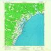
Wells ME topo map, 1:24000 Scale, 7.5 X 7.5 Minute, Historical, 1956, Updated 1967, 27.3 x 21.5 in - Tyvek
₪589.24
₪982.07
-
 Order within 15 hours and 27 minutes to get between June 11 - June 17
 -
 Tracked Shipping on All Orders
-
 14-Day Returns
- Secure Payments
-
 24/7 Customer Support
Description
- Printed on Tyvek (synthetic)
- USGS topographic map of Wells, ME, at 1:24000 scale. Lighter material. Waterproof. Tear-resistant. Foldable. Very durable. Perfect for backpacking and the outdoors.
- Cities, towns, villages: Upper Landing,Four Corners,Drakes Island,Lower Landing,Wells Branch,Cozy Corners,Kennebunk Beach,Wells,Moody Beach,Buffum Hill,Elms,Moody,Wells Beach,Moody Point,Wells Beach Station,Charles Chase Corner
- Mountains: Great Hill,Mildram Hill,Coles Hill
- Valleys: Low elevation topographic features such as flatlands, river valleys, and canyons.
Printed on Tyvek
Shipping and Returns
- We offer tracked shipping on all orders. Tracking information will be shared as soon as the order is dispatched.
- Please check the delivery estimate before adding a product to the cart. This is displayed for every product on the website.
- Available shipping methods and charges will be displayed at the time of checkout, depending on your exact location.
- All customers are entitled to a return window of 14 days, starting from the date of delivery of the product(s).
- Customers are advised to read our return policy for details of the return process, eligibility, refunds as well as cancellations or exchanges.
- In case of any issues or concerns about Shipping or Returns, please contact us and we will be happy to help.
YellowMaps.
Wells ME topo map, 1:24000 Scale, 7.5 X 7.5 Minute, Histo...
₪589.24
₪982.07