
YELLOWMAPS
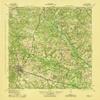
YellowMaps Aiken SC topo map, 1:62500 Scale, 15 X 15 Minute, Historical, 1943, 21.4 x 17.6 in - Polypropylene
₪536.41
₪894.02
-
 Order within 4 hours and 40 minutes to get between July 6 - July 12
 -
 Tracked Shipping on All Orders
-
 14-Day Returns
- Secure Payments
-
 24/7 Customer Support
Description
- Printed on Polypropylene (plastic)
- USGS topographic map of Aiken, SC, at 1:62500 scale. Heavier material. Waterproof. Tear-resistant. Foldable. Perfect for the outdoors.
- Cities, towns, villages: Oak Grove,Pinecrest,Bonniview Estates,Barclay Park,Montmorenci,Apia (historical),Ridgecrest,Aiken Estates,Cardinal Park,Dunbarton Oaks,Couchton,Six Points,Camp Long,Hillview,Gatewood,Quail Hollow,Westwood,Roseland,Camp Gravatt,Elmwood Park,Forest Heights,Ansley Park,Oakwood,Nicholson Village,Robinwood Estates,Merritts Bridge (historical),Seiglers Crossroads,Croft,Aiken,Ward Hills,Balltown,Earle (historical),Silver Bluff Estates,Conger Woods,Crosland Park
- Islands: Consult topo map preview for visible islands.
- Parks and forests: Virginia Acres Park,Hopeland Gardens
USGS topographic map of Aiken, South Carolina, dated 1943.
Includes geographic coordinates (latitude and longitude), lines of elevation, bodies of water, roads, and more. This topo quad is suitable for recreational, outdoor uses, office applications, or wall map framing.
Printed on-demand by YellowMaps on the print material of your choice.
Shipping rolled from Minneapolis, MN, United States.
Product Number: USGS-5388630
Map Size: 21.4 inches high x 17.6 inches wide
Map Scale: 1:62500
Map Type: POD USGS Topographic Map
Map Series: HTMC
Map Version: Historical
Cell ID: 50372
Scan ID: 261773
Woodland Tint: Yes
Aerial Photo Year: 1938
Datum: NAD27
Map Projection: Polyconic
Map published by United States Army Corps of Engineers
Map published by United States Department of War
Map Language: English
Scanner Resolution: 600 dpi
Map Cell Name: Aiken
Grid size: 15 X 15 Minute
Date on map: 1943
Geographical region: South Carolina, United States
Northern map edge Latitude: 33.75
Southern map edge Latitude: 33.5
Western map edge Longitude: -81.75
Eastern map edge Longitude: -81.5
Surrounding map sheets (copy & paste the Product No. in the search bar):
North: USGS-5388110,USGS-5388108
East: USGS-5388930,USGS-5387538,USGS-5388932
South: USGS-5388984,USGS-5388982,USGS-5387822,USGS-5387824,USGS-5387826
West: USGS-5387296,USGS-5389016,USGS-5387298,USGS-5659460,USGS-5389012
Shipping and Returns
- We offer tracked shipping on all orders. Tracking information will be shared as soon as the order is dispatched.
- Please check the delivery estimate before adding a product to the cart. This is displayed for every product on the website.
- Available shipping methods and charges will be displayed at the time of checkout, depending on your exact location.
- All customers are entitled to a return window of 14 days, starting from the date of delivery of the product(s).
- Customers are advised to read our return policy for details of the return process, eligibility, refunds as well as cancellations or exchanges.
- In case of any issues or concerns about Shipping or Returns, please contact us and we will be happy to help.
YellowMaps.
YellowMaps Aiken SC topo map, 1:62500 Scale, 15 X 15 Minu...
₪536.41
₪894.02