
YELLOWMAPS
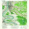
YellowMaps Baton Rouge LA topo map, 1:62500 Scale, 15 X 15 Minute, Historical, 1939, Updated 1962, 20.9 x 18 in - Polypropylene
₪531.71
₪886.18
-
 Order within 12 hours and 5 minutes to get between June 11 - June 17
 -
 Tracked Shipping on All Orders
-
 14-Day Returns
- Secure Payments
-
 24/7 Customer Support
Description
- Printed on Polypropylene (plastic)
- USGS topographic map of Baton Rouge, LA, at 1:62500 scale. Heavier material. Waterproof. Tear-resistant. Foldable. Perfect for the outdoors.
- Cities, towns, villages: Smiley Heights,Broadmoor Plaza,Beaulieu,Highland Road Estates,La Belle Aire,Southdowns,Pioneer Park,Bayou Fountain,Sarasota Place,Oxford Place,Heatherstone,Bell Grove Place,Country Manor,Perkins Place,Monterrey Park,Turnerville,Woodlawn,Sharp,Zee Zee Gardens,Villa Del Rey Park,Eliza,West River Oaks,Briarwood Estates,Lafitte Hill,Sherwood Oaks,Sunnybrook,Silverside Heights Garden,South Highland,Broadmoor Forest,Meadow Lea,Prescott Place,Westdale Heights
- Islands: Consult topo map preview for visible islands.
- Parks and forests: Valley Park (historical),Gayosa Park,Warren and Grace Farr Park,LaFitte Street Park,Lanier Drive Park,Goodwood Playground,Old State Capitol,Bird Station Park,Longfellow Park,Main Street Historic District,Spanish Town Historic District,Progress Park,East Polk Street Park,Fourtyeighth Street Park,Thomas A Maher Park,Bon Marche Community Park,Red Oaks Park,Gentilly Court Park,Belfair Park,Sharp Road Park,Duchess Drive Park,Independence Park,North Street Park
USGS topographic map of Baton Rouge, Louisiana, dated 1939, updated 1962.
Includes geographic coordinates (latitude and longitude), lines of elevation, bodies of water, roads, and more. This topo quad is suitable for recreational, outdoor uses, office applications, or wall map framing.
Printed on-demand by YellowMaps on the print material of your choice.
Shipping rolled from Minneapolis, MN, United States.
Product Number: USGS-5593536
Map Size: 20.9 inches high x 18 inches wide
Map Scale: 1:62500
Map Type: POD USGS Topographic Map
Map Series: HTMC
Map Version: Historical
Cell ID: 51010
Scan ID: 334248
Imprint Year: 1962
Woodland Tint: Yes
Edit Year: 1939
Datum: NAD
Map Projection: Polyconic
Map published by United States Geological Survey
Map published by United States Army Corps of Engineers
Map published by United States Department of War
Map Language: English
Scanner Resolution: 600 dpi
Map Cell Name: Baton Rouge
Grid size: 15 X 15 Minute
Date on map: 1939
Geographical region: Louisiana, United States
Northern map edge Latitude: 30.5
Southern map edge Latitude: 30.25
Western map edge Longitude: -91.25
Eastern map edge Longitude: -91
Surrounding map sheets (copy & paste the Product No. in the search bar):
North: USGS-5595036,USGS-5591780,USGS-5591792,USGS-5595040,USGS-5595034
East: USGS-5591614,USGS-5593906,USGS-5591620,USGS-5593898,USGS-5591618
South: USGS-5594998,USGS-5592402,USGS-5592396,USGS-5595000,USGS-5595004
West: USGS-5588022,USGS-5594130,USGS-5588016,USGS-5594134,USGS-5588024
Shipping and Returns
- We offer tracked shipping on all orders. Tracking information will be shared as soon as the order is dispatched.
- Please check the delivery estimate before adding a product to the cart. This is displayed for every product on the website.
- Available shipping methods and charges will be displayed at the time of checkout, depending on your exact location.
- All customers are entitled to a return window of 14 days, starting from the date of delivery of the product(s).
- Customers are advised to read our return policy for details of the return process, eligibility, refunds as well as cancellations or exchanges.
- In case of any issues or concerns about Shipping or Returns, please contact us and we will be happy to help.
YellowMaps.
YellowMaps Baton Rouge LA topo map, 1:62500 Scale, 15 X 1...
₪531.71
₪886.18