
YELLOWMAPS
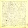
YellowMaps Bolivar MO topo map, 1:125000 Scale, 30 X 30 Minute, Historical, 1892, Updated 1906, 20 x 16.3 in - Tyvek
₪594.44
₪990.73
-
 Order within 19 hours and 18 minutes to get between July 7 - July 13
 -
 Tracked Shipping on All Orders
-
 14-Day Returns
- Secure Payments
-
 24/7 Customer Support
Description
- Printed on Tyvek (synthetic)
- USGS topographic map of Bolivar, MO, at 1:125000 scale. Lighter material. Waterproof. Tear-resistant. Foldable. Very durable. Perfect for backpacking and the outdoors.
- Cities, towns, villages: Cliquot,Preston,Hermitage,Wood Hill,Dewey (historical),Louisburg,Cloverdale,Elkton,Charity,Goodson,Burns,Nemo,Karlin,Van,Sentinel,Halfway,Polk,Ingalls (historical),Branch,Rondo,Violet,Huron,Elixer,Wishart,Almon,Sunset,Adonis,Urbana,Schofield,Tunas,Buffalo,Pumpkin Center,Huckaby,Clifford (historical),Wheatland,Rex,Pittsburg,March,Cedar Vista,Redtop,Hico (historical),Carsons Corner,Mohawk Corner,Butcher,Bolivar
- Mountains: Blue Mounds,Brushy Mound,Graveyard Hill,Blue Mound
- Valleys: Rough Hollow,Horn Hollow,Cedar Hollow,Elkhorn Hollow,Big Hollow,Todd Hollow,Cave Spring Hollow,Coatney Hollow,Sugartree Hollow
USGS topographic map of Bolivar, Missouri, dated 1892, updated 1906.
Includes geographic coordinates (latitude and longitude), lines of elevation, bodies of water, roads, and more. This topo quad is suitable for recreational, outdoor uses, office applications, or wall map framing.
Printed on-demand by YellowMaps on the print material of your choice.
Shipping rolled from Minneapolis, MN, United States.
Product Number: USGS-5575534
Map Size: 20 inches high x 16.3 inches wide
Map Scale: 1:125000
Map Type: POD USGS Topographic Map
Map Series: HTMC
Map Version: Historical
Cell ID: 65026
Scan ID: 325417
Imprint Year: 1906
Survey Year: 1884
Datum: Unstated
Map Projection: Unstated
Map published by United States Geological Survey
Map Language: English
Scanner Resolution: 600 dpi
Map Cell Name: Bolivar
Grid size: 30 X 30 Minute
Date on map: 1892
Geographical region: Missouri, United States
Northern map edge Latitude: 38
Southern map edge Latitude: 37.5
Western map edge Longitude: -93.5
Eastern map edge Longitude: -93
Surrounding map sheets (copy & paste the Product No. in the search bar):
North: USGS-5575852,USGS-5574652,USGS-5580094,USGS-8618806,USGS-5580096
East: USGS-5679661,USGS-5679665,USGS-5578944,USGS-5679663
South: USGS-5575798,USGS-8618714,USGS-5579382,USGS-5575794,USGS-5579384
West: USGS-5575806,USGS-8618732,USGS-5575974,USGS-5575972,USGS-8618250
Shipping and Returns
- We offer tracked shipping on all orders. Tracking information will be shared as soon as the order is dispatched.
- Please check the delivery estimate before adding a product to the cart. This is displayed for every product on the website.
- Available shipping methods and charges will be displayed at the time of checkout, depending on your exact location.
- All customers are entitled to a return window of 14 days, starting from the date of delivery of the product(s).
- Customers are advised to read our return policy for details of the return process, eligibility, refunds as well as cancellations or exchanges.
- In case of any issues or concerns about Shipping or Returns, please contact us and we will be happy to help.
YellowMaps.
YellowMaps Bolivar MO topo map, 1:125000 Scale, 30 X 30 M...
₪594.44
₪990.73