
YELLOWMAPS
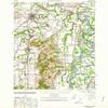
YellowMaps McMinnville OR topo map, 1:62500 Scale, 15 X 15 Minute, Historical, 1940, Updated 1963, 21.9 x 16.7 in - Polypropylene
₪536.41
₪894.02
-
 Order within 3 hours and 36 minutes to get between July 6 - July 12
 -
 Tracked Shipping on All Orders
-
 14-Day Returns
- Secure Payments
-
 24/7 Customer Support
Description
- Printed on Polypropylene (plastic)
- USGS topographic map of McMinnville, OR, at 1:62500 scale. Heavier material. Waterproof. Tear-resistant. Foldable. Perfect for the outdoors.
- Cities, towns, villages: Bethel,Bethel Heights,Saint Joseph,Lakebrook,Dayton,Wheatland,Clear Lake,McMinnville,Eola Crest,McCoy,Eola Village,Whiteson,Zena,Amity,Hopewell,Lafayette,Fairfield,Unionvale,Lincoln
- Islands: Windsor Island,Coffee Island,Grand Island,Five Islands
- Parks and forests: Wilark County Park,Joel Perkins Park,Wortman Park,Crestwood Park (historical),Tice Park,James Park,Kingwood Mini Park,Discovery Meadows Community Park,11th Street Park,Fort Yamhill State Park,Dayton Boat Landing,Courthouse Square Park,San Salvador Access,Northside County Park,North Evans Mini Park,Legion Field,Joe Dancer Park,Alderman Park,Northridge Park,Westvale Park,Jason Lee Mission Historical Marker,Carlson Park (historical),Alderman Park
USGS topographic map of McMinnville, Oregon, dated 1940, updated 1963.
Includes geographic coordinates (latitude and longitude), lines of elevation, bodies of water, roads, and more. This topo quad is suitable for recreational, outdoor uses, office applications, or wall map framing.
Printed on-demand by YellowMaps on the print material of your choice.
Shipping rolled from Minneapolis, MN, United States.
Product Number: USGS-5545060
Map Size: 21.9 inches high x 16.7 inches wide
Map Scale: 1:62500
Map Type: POD USGS Topographic Map
Map Series: HTMC
Map Version: Historical
Cell ID: 57407
Scan ID: 282704
Imprint Year: 1963
Woodland Tint: Yes
Edit Year: 1947
Datum: NAD27
Map Projection: Transverse Mercator
Map published by United States Geological Survey
Map published by United States Army
Map published by United States Department of War
Map Language: English
Scanner Resolution: 600 dpi
Map Cell Name: McMinnville
Grid size: 15 X 15 Minute
Date on map: 1940
Geographical region: Oregon, United States
Northern map edge Latitude: 45.25
Southern map edge Latitude: 45
Western map edge Longitude: -123.25
Eastern map edge Longitude: -123
Surrounding map sheets (copy & paste the Product No. in the search bar):
North: USGS-5545624,USGS-5417212,USGS-5545620,USGS-5545622,USGS-5417210
East: USGS-5418664,USGS-5418668,USGS-5545120,USGS-5545122,USGS-5545124
South: USGS-5545314,USGS-5421190,USGS-5545318,USGS-5545310,USGS-5678246
West: USGS-5416520,USGS-5545354,USGS-5416518,USGS-5416524,USGS-5545352
Shipping and Returns
- We offer tracked shipping on all orders. Tracking information will be shared as soon as the order is dispatched.
- Please check the delivery estimate before adding a product to the cart. This is displayed for every product on the website.
- Available shipping methods and charges will be displayed at the time of checkout, depending on your exact location.
- All customers are entitled to a return window of 14 days, starting from the date of delivery of the product(s).
- Customers are advised to read our return policy for details of the return process, eligibility, refunds as well as cancellations or exchanges.
- In case of any issues or concerns about Shipping or Returns, please contact us and we will be happy to help.
YellowMaps.
YellowMaps McMinnville OR topo map, 1:62500 Scale, 15 X 1...
₪536.41
₪894.02