
YELLOWMAPS
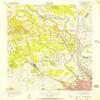
YellowMaps North Shreveport LA topo map, 1:24000 Scale, 7.5 X 7.5 Minute, Historical, 1955, Updated 1956, 26.8 x 22.9 in - Tyvek
₪594.44
₪990.73
-
 Order within 4 hours and 27 minutes to get between July 6 - July 12
 -
 Tracked Shipping on All Orders
-
 14-Day Returns
- Secure Payments
-
 24/7 Customer Support
Description
- Printed on Tyvek (synthetic)
- USGS topographic map of North Shreveport, LA, at 1:24000 scale. Lighter material. Waterproof. Tear-resistant. Foldable. Very durable. Perfect for backpacking and the outdoors.
- Cities, towns, villages: Lakeview,Shreveport,North Shreveport,Dorian Terrace,Indian Hills Estates,Lakeside Acres,Pine Hill Estates,Highland Square,One North Place,Hanna Park,Northwoods,Conn,North Highlands,Gas Center,Good Roads,Cash Point,Audrey Park,Cooper Road,Albany (historical)
- Mountains: Pine Hills
- Valleys: Low elevation topographic features such as flatlands, river valleys, and canyons.
USGS topographic map of North Shreveport, Louisiana, dated 1955, updated 1956.
Includes geographic coordinates (latitude and longitude), lines of elevation, bodies of water, roads, and more. This topo quad is suitable for recreational, outdoor uses, office applications, or wall map framing.
Printed on-demand by YellowMaps on the print material of your choice.
Shipping rolled from Minneapolis, MN, United States.
Product Number: USGS-5591280
Map Size: 26.8 inches high x 22.9 inches wide
Map Scale: 1:24000
Map Type: POD USGS Topographic Map
Map Series: HTMC
Map Version: Historical
Cell ID: 32378
Scan ID: 332956
Imprint Year: 1956
Woodland Tint: Yes
Survey Year: 1955
Datum: NAD27
Map Projection: Polyconic
Map published by United States Geological Survey
Map published by United States Army Corps of Engineers
Map Language: English
Scanner Resolution: 600 dpi
Map Cell Name: North Highlands
Grid size: 7.5 X 7.5 Minute
Date on map: 1955
Geographical region: Louisiana, United States
Northern map edge Latitude: 32.625
Southern map edge Latitude: 32.5
Western map edge Longitude: -93.875
Eastern map edge Longitude: -93.75
Surrounding map sheets (copy & paste the Product No. in the search bar):
North: USGS-5593322,USGS-5589134
East: USGS-5588496,USGS-5588506,USGS-5588494,USGS-5588498,USGS-5588504
South: USGS-5591830,USGS-5591826,USGS-5591820,USGS-5591822,USGS-5591824
West: USGS-5588448,USGS-5588446
Shipping and Returns
- We offer tracked shipping on all orders. Tracking information will be shared as soon as the order is dispatched.
- Please check the delivery estimate before adding a product to the cart. This is displayed for every product on the website.
- Available shipping methods and charges will be displayed at the time of checkout, depending on your exact location.
- All customers are entitled to a return window of 14 days, starting from the date of delivery of the product(s).
- Customers are advised to read our return policy for details of the return process, eligibility, refunds as well as cancellations or exchanges.
- In case of any issues or concerns about Shipping or Returns, please contact us and we will be happy to help.
YellowMaps.
YellowMaps North Shreveport LA topo map, 1:24000 Scale, 7...
₪594.44
₪990.73