
YELLOWMAPS
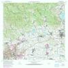
YellowMaps Ponce PR topo map, 1:20000 Scale, 7.5 X 7.5 Minute, Historical, 1970, Updated 1982, 32.8 x 28.9 in - Tyvek
₪632.74
₪1,054.57
-
 Order within 19 hours and 19 minutes to get between July 7 - July 13
 -
 Tracked Shipping on All Orders
-
 14-Day Returns
- Secure Payments
-
 24/7 Customer Support
Description
- Printed on Tyvek (synthetic)
- USGS topographic map of Ponce, PR, at 1:20000 scale. Lighter material. Waterproof. Tear-resistant. Foldable. Very durable. Perfect for backpacking and the outdoors.
- Cities, towns, villages: Coto Laurel,Calzada Comunidad,Hacienda Yani,Altavista,Los Almendros,La Rambla,Vayas,Villa Machuelo,Cerrillos Hoyos Comunidad,Valle Alto,Extensin Mariani,Hacienda Rosal,Guayabal,Hacienda Guayo,Villa Elena,Jardines de Ponce,San Antn,El Paraiso,Hacienda Potala,Villa del Sol,El Viga,Jacaguas,Hacienda Usera,Ollas Hondas,Maragez,Palmarejo,Hacienda Barrancas,Hacienda Arbona,Collores,Ponce de Len,Hacienda Restaurada,El Paraiso Comunidad,Ars,Canterra
- Mountains: Cerro Augustinillo,Monte Figueroa,Pico Pinto,Cerro el Vigia,La Mesa,Cerro El Gato,Cerro Los Negrones,Cerro Santo Domingo
- Valleys: Quebrada Jageyes,Quebrada Ausubo,Quebrada de los Giros,Quebrada Indalecia,Quebrada Chorrera,Quebrada Guanbana,Quebrada Chiquita
USGS topographic map of Ponce, Puerto Rico, dated 1970, updated 1982.
Includes geographic coordinates (latitude and longitude), lines of elevation, bodies of water, roads, and more. This topo quad is suitable for recreational, outdoor uses, office applications, or wall map framing.
Printed on-demand by YellowMaps on the print material of your choice.
Shipping rolled from Minneapolis, MN, United States.
Product Number: USGS-5654920
Map Size: 32.8 inches high x 28.9 inches wide
Map Scale: 1:20000
Map Type: POD USGS Topographic Map
Map Series: HTMC
Map Version: Historical
Cell ID: 35930
Scan ID: 362200
Imprint Year: 1982
Woodland Tint: Yes
Photo Revision Year: 1982
Aerial Photo Year: 1977
Edit Year: 1982
Field Check Year: 1970
Datum: Puerto Rico
Map Projection: Polyconic
Map published by United States Geological Survey
Map Language: English
Scanner Resolution: 600 dpi
Map Cell Name: Ponce
Grid size: 7.5 X 7.5 Minute
Date on map: 1970
Geographical region: Puerto Rico, United States
Northern map edge Latitude: 18.125
Southern map edge Latitude: 18
Western map edge Longitude: -66.625
Eastern map edge Longitude: -66.5
Surrounding map sheets (copy & paste the Product No. in the search bar):
North: USGS-5655330,USGS-5655336,USGS-5654798,USGS-5654796,USGS-5655338
East: USGS-5654980,USGS-5655512,USGS-5654976,USGS-5655510,USGS-5654978
South: USGS-5655444,USGS-5655440,USGS-5654904,USGS-5654906,USGS-5654902
West: USGS-5654900,USGS-5654892,USGS-5654896,USGS-5654894,USGS-5655434
Shipping and Returns
- We offer tracked shipping on all orders. Tracking information will be shared as soon as the order is dispatched.
- Please check the delivery estimate before adding a product to the cart. This is displayed for every product on the website.
- Available shipping methods and charges will be displayed at the time of checkout, depending on your exact location.
- All customers are entitled to a return window of 14 days, starting from the date of delivery of the product(s).
- Customers are advised to read our return policy for details of the return process, eligibility, refunds as well as cancellations or exchanges.
- In case of any issues or concerns about Shipping or Returns, please contact us and we will be happy to help.
YellowMaps.
YellowMaps Ponce PR topo map, 1:20000 Scale, 7.5 X 7.5 Mi...
₪632.74
₪1,054.57